
Mount Erie is the highest point on Fidalgo Island, and you can drive up it — but the hike is better
Most summit views make you earn them. Mount Erie in Anacortes hands you the keys to a narrow paved road instead, and that is exactly why the hike up is the better move. You get the same panorama over the San Juan Islands and the Cascades, plus a forest walk that makes the payoff feel like it counts.
Mount Erie is the highest point on Fidalgo Island, and the summit has a small parking lot and restrooms. So who needs boots? Stick with me.
Psst — we made you a West Coast Adventure Map. Nearly 1,900 of our favorite spots, already pinned, ready to load into Google Maps in two clicks — grab it here.
The view from the top
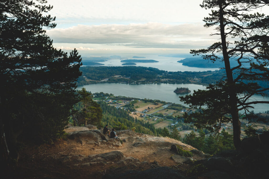
From the summit viewpoints you look out over the Puget Sound lowlands, the San Juan Islands, and out toward the Cascade and Olympic ranges. Lake Erie, Lake Campbell, and Whistle Lake sit in the forest below like puddles somebody left on purpose. It is the kind of view that makes you stop mid-sentence.

The summit road is narrow and paved, and the lot up top holds roughly 25 cars. Rock climbers use Mount Erie too, so keep an eye on traffic and never toss anything over the edge of a viewpoint.
📍 GET THE ULTIMATE PNW MAP 🗺️
Get our curated list of the best adventures, things to do, and places to grab a brew loaded onto your maps with just two clicks!
✅ Waterfalls ✅ Hikes ✅ Viewpoints
✅ Craft breweries ✅ National Parks ✅ 1400+ Pins


Why I would walk it anyway
Here is my one confident opinion: park at the Heart Lake Road trailhead and hike. The shortest route is about 5 miles round trip with roughly 1,000 feet of climbing, which is a moderate effort, not a suffer-fest. Mossy pines, maples, and alders line the way, and the summit view feels like a reward instead of a drive-through window.
Want more mileage? The Mount Erie and Sugarloaf loop runs about 7.3 miles with around 1,200 feet of gain, and it drops down past Heart Lake before you finish. Some stretches are steep and rocky, and they get slick when wet, so wear shoes with real grip.
Go bigger in the Community Forest
Mount Erie sits inside the Anacortes Community Forest Lands, more than 2,800 acres with about fifty miles of marked trails. The Four Summit Loop strings together Little Round Top, Sugar Cube, Mount Erie, and Sugarloaf in roughly 6.5 miles, with about 1,700 feet of gain. That one is rated moderate to hard, so pack water and give yourself a real chunk of the day.
The land belongs to the City of Anacortes, and no parking pass is required. Dogs are welcome on leash, and the trails add white fawn lilies in spring and fall foliage later in the year.
Make a day of Fidalgo
Pair this with the rest of the island using our guide to things to do on Whidbey and Fidalgo Islands. If summit views are your thing, the San Juans have a bigger one: Mount Constitution on Orcas Island is the highest point in that archipelago.
So which will you pick: the lazy drive or the forest climb? Tell us in the comments how you took on Mount Erie.
Trip tips: grab a rental car to get out here, lock in your hotel before the good rooms are gone, or skip both and book a camper van instead.
Rules and fees change — always confirm current requirements before you go.