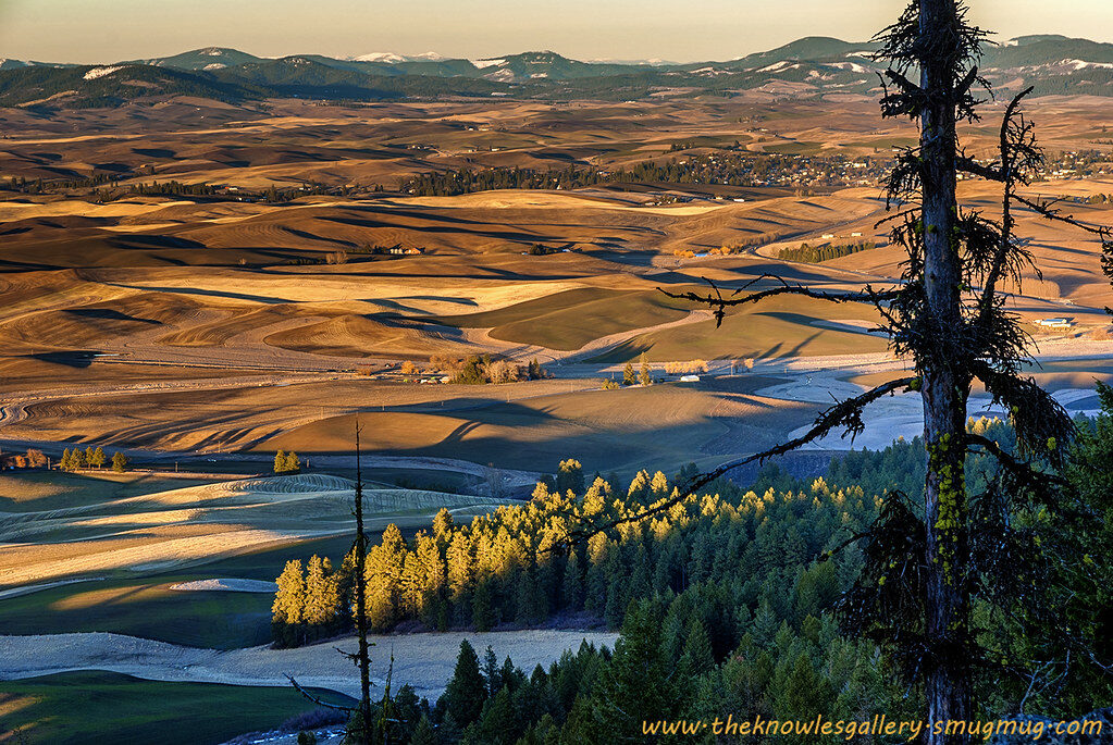
Kamiak Butte is a forested island rising 1,000 feet out of Palouse wheat fields, and the loop to the top is only 3.5 miles
Most people drive right past this one. That’s a mistake, because rising out of the Palouse’s rolling wheat fields is a forested butte that looks like it was airlifted in from the west side of the state.
Kamiak Butte tops out at about 3,640 feet, roughly 1,000 feet above the farmland around it. The loop that takes you up and over it is just 3.5 miles. Picture it: Douglas fir and ponderosa pine overhead, and then the trees open and the whole Palouse unrolls below you like a quilt.
Psst — we made you a West Coast Adventure Map. Nearly 1,900 of our favorite spots, already pinned, ready to load into Google Maps in two clicks — grab it here.
Why a forest is growing in the middle of wheat country
Kamiak Butte is made of ancient quartzite, a seafloor deposit that was nearly swallowed by the lava flows that later covered Eastern Washington. The butte poked through, and it’s been standing above the fields ever since. That’s also why the forest on top feels so out of place, with a mix of trees you’d expect near Puget Sound rather than near Pullman.
The park covers 298 acres in Whitman County, between the towns of Palouse and Pullman. It’s named for Kamiakin, a Yakama war chief in the 1850s, and it’s recognized as a National Natural Landmark. More than 170 plant species grow here, which is a lot for one butte.
📍 GET THE ULTIMATE PNW MAP 🗺️
Get our curated list of the best adventures, things to do, and places to grab a brew loaded onto your maps with just two clicks!
✅ Waterfalls ✅ Hikes ✅ Viewpoints
✅ Craft breweries ✅ National Parks ✅ 1400+ Pins


The Pine Ridge loop, step by step
The classic route is the Pine Ridge Trail, a 3.5-mile loop that climbs through the forest, follows the ridgeline, and then drops back down on switchbacks. A short spur takes you to the true summit, where a picnic table is waiting. Yes, someone put a picnic table at the top of a mountain, and I fully support it.
Here’s my one firm opinion: take the loop counterclockwise. It’s the direction that’s easier on your knees, and the long ridge section with the Palouse views is a better reward when you’re not already limping. Want more of a workout? Go clockwise and earn it.
There are also other trails in the park, adding up to more than five miles in all, including the West End Trail from the upper parking area and a steeper, more direct Backside Trail to the summit. Dogs are allowed on a leash, and no parking pass is required. Start early if the day looks warm, since the trail can get hot.
When to go
Spring is when this place really shows off, with fresh green fields and wildflowers along the trail. That said, the farmland views hold up year-round, so a fall or winter visit still delivers a big, wide-open horizon. Weekends can bring families out by late morning, so an early start gets you the ridge mostly to yourself.
Stay the night
The park has a first-come, first-served campground that’s open year-round, with no reservation system. Whitman County lists camping at $25 per night, plus $5 for a second vehicle. Fire restrictions are put in place each year as fire season dictates, so check what’s posted at the park before you plan on a campfire.
Make it a Palouse day
Pair the butte with a bigger Eastern Washington road trip. Palouse Falls State Park is worth adding to the route, and our guide to Eastern Washington has plenty more ideas for filling out the weekend.
So what do you think: is a forested butte in the middle of wheat country the most surprising hike in the state? Tell us where you’d send a first-timer in Eastern Washington.
Trip tips: grab a rental car to get out here, lock in your hotel before the good rooms are gone, or skip both and book a camper van instead.
Rules and fees change — always confirm current requirements before you go.